2026 is the 180th anniversary of the closure of one of the world’s earliest public railways. It wasn’t a passenger carrying railway however. The Surrey Iron Railway was officially closed on 31st August 1846. Its traffic had been considerably low for at least two decades prior to that date and in the final years there had been little traffic. Despite a promising beginning the railway had never really been a success. Indeed there was recognition the line would never “pay interest for the money laid out in constructing it”. (Colonist and Commercial Weekly Advertiser, 16th January 1825). In 1830 an observer said the railway had no traffic, plus weed and grass had grown over the tracks. (The Sun, London, 27th April 1830).
Since there is nothing that cannot be known about what is one of the world’s earliest public railways, and certainly the first such to be built in the metropolis area, being one that attempted to be different to any others, one must ask why is it that a substantial part of route the railway has been altered considerably? That as well as the prevalent and accepted history being blighted somewhat. This series of information boards on the Surrey Iron Railway (and its extension the Croydon, Merstham and Godstone Iron Railway) are replete with many errors including the depicted alignments taking on new routes which were not ever part of the original railway!
If anyone’s spotted the error on the above map they’ll be pretty well aware what this post is about! First off, the information boards should ideally refer to the Croydon, Merstham and Godstone Iron Railway. However ‘Surrey Iron Railway’ is a far wider and more recognised name. It does render the boards somewhat inaccurate however.
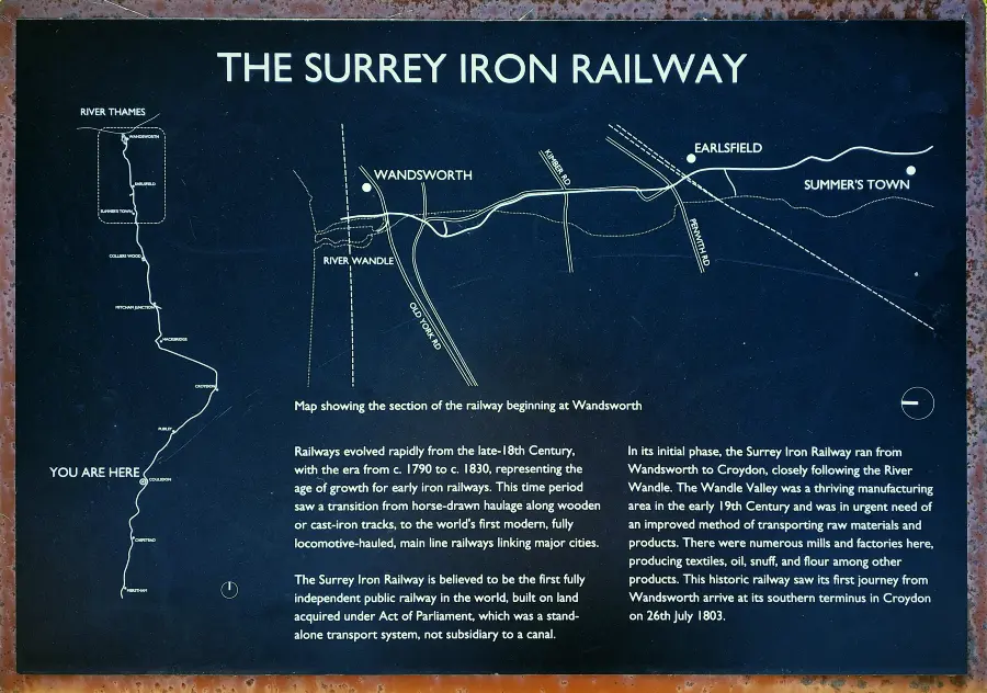
The SIR from Wandsworth is okay except Summerstown which should be on the east side of the line. A result of that is the railway heads in the wrong direction. The information here suggests the railway was the first example of its kind in the world. It depends on what is being insinuated by that claim.
This concerns a set of information boards covering the famous iron railway in north Surrey. These boards are pretty new and were put up possibly summer of 2024, although there is nothing to indicate exactly when they were installed. It is commendable that an attempt to at least regale the history of the Surrey, and the Croydon, Merstham and Godstone, Iron Railways has been made, especially as information boards seem to disappear quite quickly. These new boards are mounted on iron plinths and are intended to be sturdy.
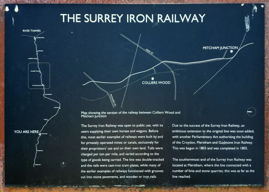
From The Mead to Wandle Nature Park this looks okay. However Colliers Wood’s in the wrong place! Plough Lane goes in the wrong direction. It is somewhat wrong to suggest the southern end of the Surrey Iron Railway was at Merstham. In an overall sense the entire line would have extended as far as Merstham, however it was operated as two legally separate concerns.
The first two examples are not too bad despite some errors. The last three boards, the route depicted is certainly right off the mark! Whoever designed these boards had somehow seen that the whole Surrey Iron Railway had gone via Hackbridge, somewhat following the River Wandle in part. The fact is the Surrey Iron Railway never took this route. It did have a branch from Mitcham to Hackbridge, however the main route went straight from Mitcham to Croydon via what now constitutes in large the Croydon tramlink route.
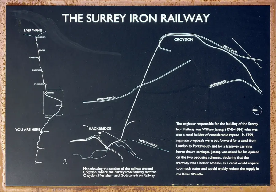
Beyond Mitcham however, the route of the railway is totally wrong! Beddington Lane’s not on the alignment depicted! Brighton Road is shown as going across the railway to the east where in real life it never does that. See below for how this arrangement looks when overlaid on a modern map.
The route depicted through Croydon and South Croydon, well it seems impossible to make head or tail of it! I’ve tried to overlay it on current maps with a bit of tweaking. The section between Hackbridge and Croydon does at least tie up with the actual railway’s course at both ends – even though the route shown in between is just so way off. As for the continuing section south to Purley, the route represented is simply not how it was in reality.
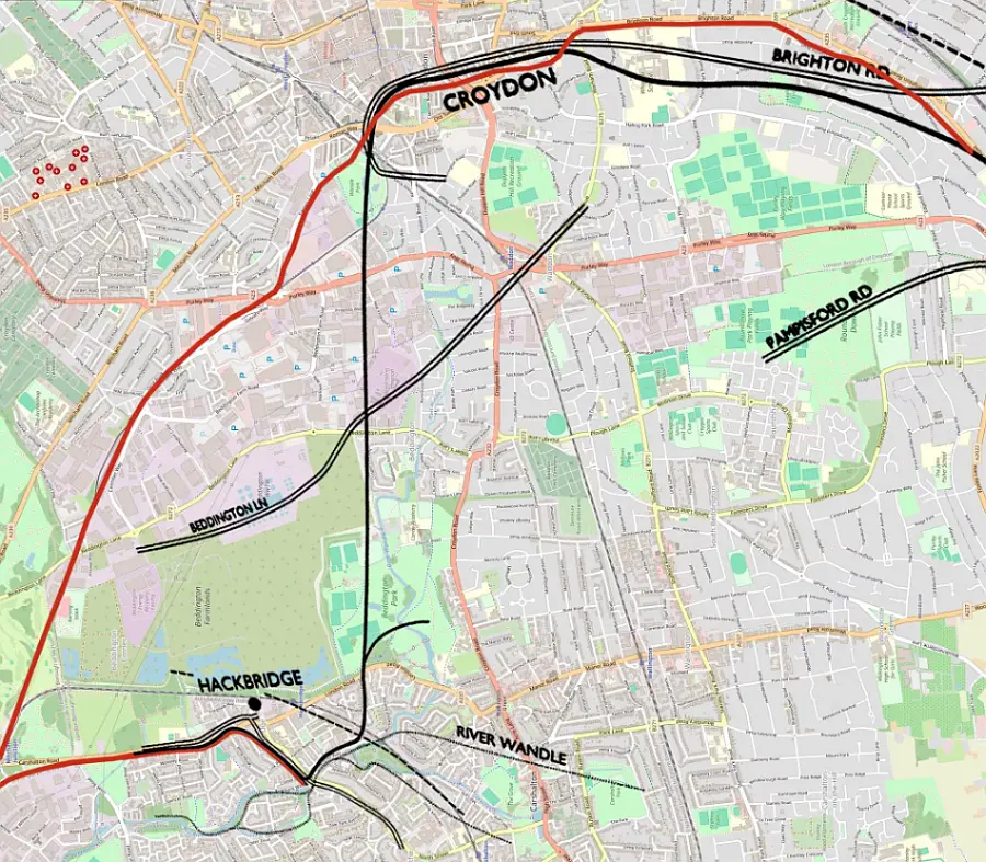
Voila! A map has been produced showing where the alleged course of the iron railway meets the true alignment at Mitcham Junction, Hackbridge, Croydon and Purley Oaks. The accepted course of the iron railway (as marked on old OS maps) is depicted in red – and a substantial part of that (Mitcham to Waddon Marsh) is used by the Croydon tramlink. The iron railway most certainly did not go from Mitcham to Croydon via Hackbridge. It was very difficult to overlay and align the erroneous map to specific points on the Open Street map shown here. Don’t ask what the intent of showing Beddington Lane and Pampisford Roads on such bizarre alignments was!
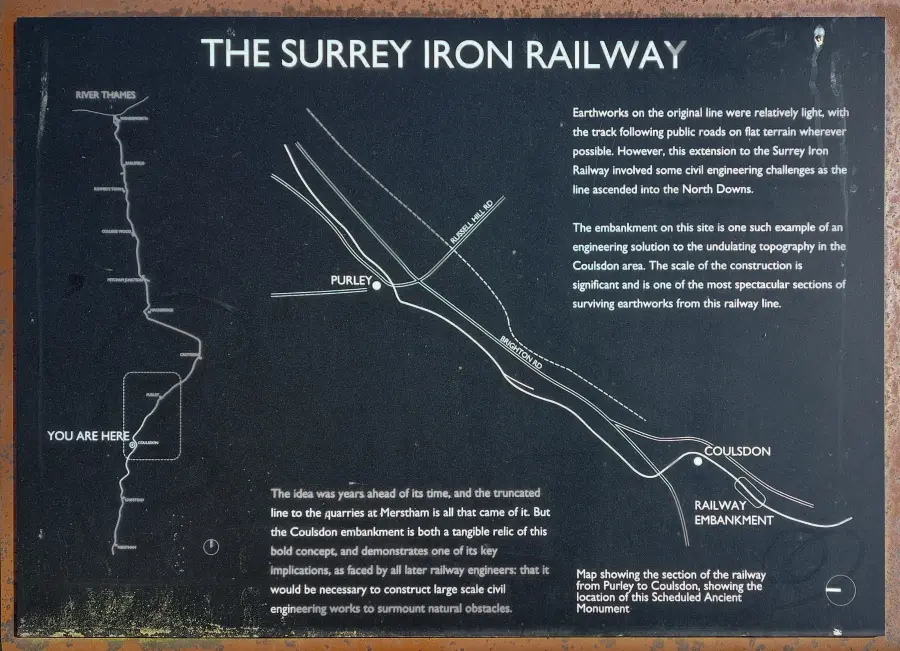
Still wrong as the line continues through Cousldon. The embankment is depicted at the wrong location, whilst Coulsdon is slightly out.
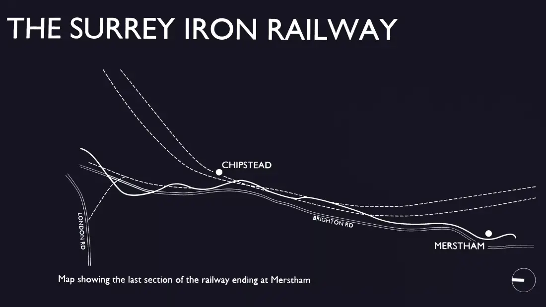
The section onwards through Coulsdon also deserves criticism because the historic listed Iron Railway embankment is in entirely the wrong location! And the final section through Hooley and Merstham well, that’s just not how it went! The line is shown as going to the west side of Merstham – when it in fact didn’t touch Merstham and the route veered to the east instead.
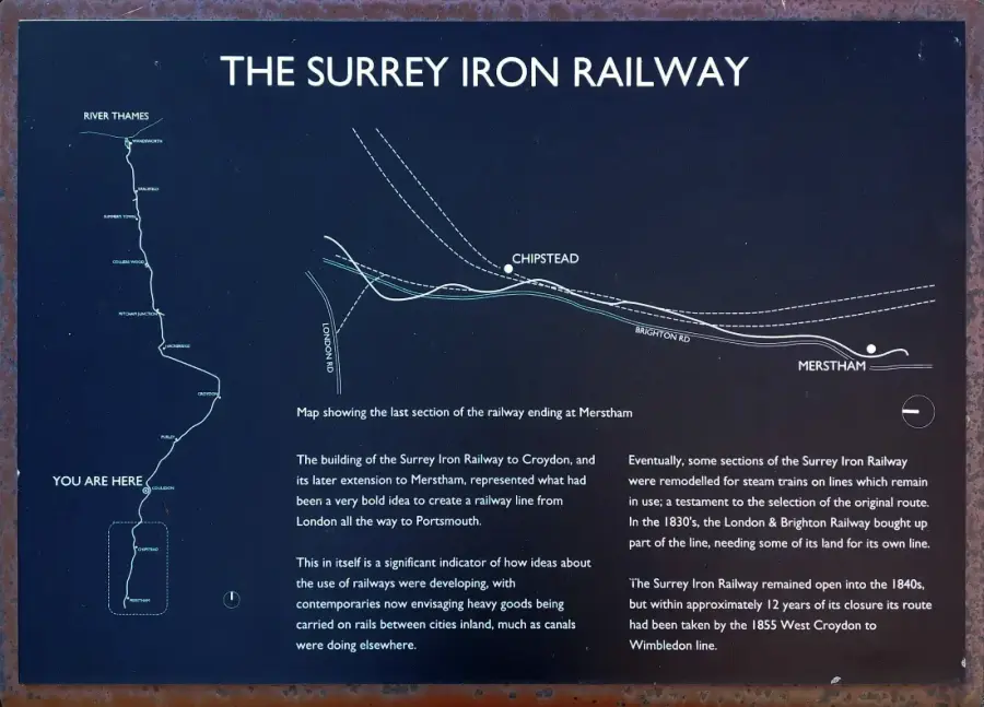
Even to the very end of the line the mapping gets it wrong! Chipstead is not even where its said to be! Amazingly the board informs that the route of the iron railway was later taken over by the West Croydon to Wimbledon line. Its amazing this is not even depicted on the third information board in the series depicted above!
If people are serious about commemorating and/or depicting the history and course of the iron railway, they jolly well ought to research things properly!
To be continued…
Leave a Reply