The picturesque upper Lötschental is where the recent calamity involving the village of Blatten occurred. It is a disaster of gigantic proportions and the huge avalanche and mud slide from the Birch glacier has buried the village to a depths of between 50 and 200 metres. That’s pretty deep if one thinks about it. Fifty metres is 165 feet in imperial measure, and at the other end of the scale its 656 feet of debris piled above parts of the village.
The local roads have been cut off as has the valley’s river, the Lonza. In short it is an unmitigated environmental disaster and in many respects its a cause of global warming – although there are other factors at play too. The nearest the avalanche site is to any railway is that at Goppenstein which is around 6.5km or four miles distant. This part of the Lötschental is where one of Switzerland’s most important main lines – the Bern–Lötschberg–Simplon – can be found. One would think Goppenstein is somehow untouched by the disaster, but that is not the case for it has certainly been affected – the road out of the village into the Lötschental is closed completely.

Due to current natural events in Blatten, the road from Goppenstein in the direction of Fafleralp is closed. We thank you for your understanding. Lötschental website.
The Bern–Lötschberg–Simplon has its route through the lower part of the Lötschental and this also entails the major station at Goppenstein, sited at the southern entrance to the classic Lötschberg tunnel. Nowadays the main bulk of traffic (including car ferrying) travels through the newer Lötschberg base tunnel thus this section of the Bern–Lötschberg–Simplon is not affected. Nevertheless the classic railway route remains an important link in the Swiss transport system.
Goppenstein with the classic Lötschberg tunnel at left and the adjacent short road tunnel which leads into the upper Lötschental towards Blatten. Currently many (including tourists) cannot venture beyond Goppenstein due to the Blatten incident. The Lonza river is at left and considerably lower down than the railway. This is where the river is at its nearest to the railway than at this point. Fortunately the railway tunnel entrance faces downstream which places it out of the way of any possible incursion from flooding. In addition to that the tunnel itself is also on a rising gradient as the Bern–Lötschberg–Simplon’s summit happens to be midway through the tunnel. The combination of these slopes would no doubt mean it would be very difficult for the railway to be affected by any possible flood from the Blatten disaster. As things stand, it seems the situation has eased somewhat and the risk of flooding has lessened.

Profile of the Bern–Lötschberg–Simplon between Brig and Spiez. The Lötschberg tunnel is clearly shown with its profile rising either side of the line’s summit midway through the tunnel – the highest point on the standard gauge Swiss system at 1,240 metres (4070 feet) above sea level. Wikipedia.
Even though both the Bern–Lötschberg–Simplon and the Lonza river descend towards the Rhône valley, this part of the Lötschental sees the railway maintain a higher elevation thus there is a little risk of any problems arising – unlike other Swiss railways that might need to follow a river quite closely. This is the case of the nearby line to Zermatt as we shall find out later.
In terms of the classic Lötschberg railway, there does not seem to be any concerns at the moment except possibly at the other end of the tunnel in Kandersteg. The Swiss are extremely well prepared for any other possible effects that might arise as a result of the Blatten incident – or any other mountains/glaciers.
There has been discussion on the possible effects of the Blatten calamity on the Swiss railways including the Lötschberg line and the main SBB route lower down in the Rhône valley. The Lötschberg base tunnel’s southern entrance is a short distance east of Visp in the Rhône valley itself so this is pretty well away from the lower end of the Lötschental – around 7km or four and half miles. The main SBB route from Brig to Geneva does however run past where the Lötschental enters the Rhône – as shown below. However this point of confluence is currently thought to be too far away for any possible effects to occur. The biggest concern at the moment on any of the Swiss forums is the possibility that any subsequent flooding might affect Goppenstein and its railway. As indicated earlier it looks as if the situation is improving.
Presently the situation is there will be no flooding that shall occur further down the Lötschental – and that is because the floodwater that had been building up behind the Blatten debris has now been observed to be receding. Its not any sort of relief however because the authorities are unable to give the all-clear and assert the threat from flooding has receded. (Independent 31st May 2025).
The Swiss have been monitoring their glaciers for decades and the possibility of substantial movement in the Birch glacier had been known sometime before the actual event had occurred. The inhabitants of Blatten were moved out a week before the avalanche ensued. In terms of flooding and how that might possibly affect the railway, its likely the authorities would be sufficiently prepared so as to build a temporary wall at a couple of locations, one being at the upper end of the road tunnel and the other at Goppenstein itself in order to ensure any water was deflected properly.
Kandersteg railway station – with the mountains behind that are currently a cause for concern.
Goppenstein might not have great difficulties facing it at the moment, however the other end of the Lötschberg tunnel is to be found at Kandersteg and compared to Goppenstein there’s a whole different kettle of fish at play here. The Spitzer Stein mountain above Kandersteg is a continuing threat to the village and its Bern–Lötschberg–Simplon line. No new buildings can be erected and parts of the village are classed a red or orange danger area. The railway station area is classed as a site where flooding and mudflows could occur. (Swiss Info). Evidently the Bern–Lötschberg–Simplon railway passes through an area that faces a greater threat than the other end of the line’s long tunnel – and its the mountains surrounding the village that is the problem. (Beobatcher).
The issue of global warming and glacial erosion is something that is regularly debated in terms of Switzerland and there are companies whose business is to maintain the country’s defences and make sure that no harm comes to any of the country’s communities – especially where a mountain or a glacier is known to be on the move.
There is recognition that some of the instances that have occurred are certainly due to natural erosion. To say they are directly a result of global warming is perhaps too premature as one expert puts it. Erosion has been occurring for thousands of years and some of these events will have no doubt been principiated by global warming – in other words they have been accelerated. (Swiss Info).
As is evidenced from the above Google view, the Lötschental enters the broad Rhône valley. The SBB line is to the south so that would not be affected. However its not simply a case of the railways that is cause for concern. All the area’s villages and towns will have some cause for concern no matter how small it is at the moment, and its those in the Lötschental below Blatten that have the biggest concerns currently.
A number of avalanches do occur each year in the Swiss mountains, and these are either due to snow or rockfalls. The Swiss are however greatly prepared and they work with a view to preventing loss of life and mitigating the amount of damage that could occur. This short video from Tom Scott on Youtube shows the amount of dedication that is aimed at reducing landslides avalanches, and even though the case Tom Scott highlights is a small one, it shows the Swiss are at the top of the league in terms of their expertise. Despite these great precautions, the village shown in the video which was Brienz, was hit by a huge landslide in 2024. Its inhabitants had however been evacuated sometime earlier in anticipation of this event. Nevertheless, the calamity closed the adjacent Rhaetian Railway. In terms of the railways there are measures in place to prevent calamities affecting the lines or any trains that might be about when issues do arise – such as shown on this Youtube video.
The Canton of Valais – which both Blatten and Zermatt are part – has seen huge avalanches in the past – and one such example occurred not too far away at Randa in the Zermatt valley. This occurred in 1991 and the amount of debris in that instance amounted to 30 million cubic metres of debris – more than that which affected Blatten. The Brig-Visp-Zermatt railway (or as is known these days, the Matterhorn-Gotthardbahn) was totally blocked and the line was shut for months.
More recently rainfall and huge avalanches cut off Zermatt and flooded the town considerably as well as closing off the valley and the railway too. One of the most concerning videos to come out of one of those instances was this film from 2018 (and reissued recently) showing a Matterhorn-Gotthard train avoiding the flooding that would inundate the railway. Just last year, the line was closed for many weeks due to major flooding (Swiss Info).
The possibility that any railway could be affected is not something to be dismissed lightly. Zermatt is a car-free town and that is important in terms of the mountain ecology as well as fighting global warming. Its inhabitants rely on the railway as the sole means of transport – and there are other towns in Switzerland too (Murren, Wengen and Stoos among others) that are car-free and have a total reliance on railways or cable cars. The local public transport systems are essential in terms of reducing the impact on the environment – and even more so where even the country’s numerous road building and upgrade schemes in the more populous cantons have not exactly helped in terms of emissions and other pollutants such as particles from vehicle tyres and brakes – as well as the concrete used in roads construction and the rest of it. Thus there will no doubt be substantial concern if these main transport arteries that are an important alternative to the roads and a valuable lifeline for the mountain communities that are served, were to be compromised. Blatten no doubt shows the shocking extent to which idyllic life in the mountains can be turned completely to one of horror.
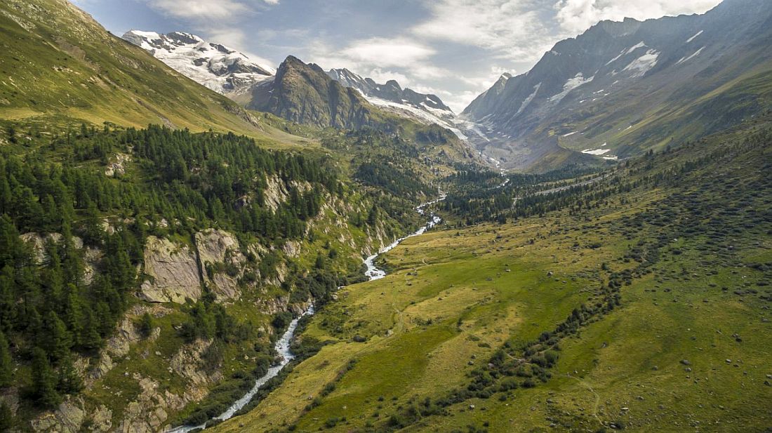
The main feature image is of the upper Lötschental to the east of Blatten and is from the Lötschental tourism website.
Leave a Reply